
Elevation Finder
How high above sea level are you? This elevation finder gives three ways to find out without sending your location anywhere: your device’s own GPS altitude (on phones and tablets that report it), a barometric reading converted with the standard atmosphere formula, or a list of approximate elevations for well-known places. Then it shows what the height means for air pressure, cooking and breathing.
- Free to use
- No sign-up
- Runs in your browser
Elevation finder
Location is read only in your browser and never sent to us. GPS altitude is often less accurate than horizontal position (errors of ±10–50 m are common), and desktop browsers usually don’t report altitude at all.
High-Altitude Reference Pack
Printable altitude reference: pressure and boiling point by elevation, a high-altitude baking adjustment card and an acclimatisation planning sheet.
- Reference table (PDF/XLSX)
- Baking card (PDF)
- Trip plan (PDF/DOCX)
Formats: PDF, XLSX, DOCX. Instant download after payment (link valid 72 hours, up to 5 downloads). AI-assisted: the templates were drafted with AI help and reviewed and laid out before publishing.
$5.00 USD, one-time 3 files · about $1.67 each
- Instant download
- 7-day refund
- Secure checkout by Stripe
7-day money-back guarantee. Full refund within 7 days of purchase, even after you download.
Full refund within 7 days — see the refund policy and license.
Free printables
Single sheets you can print right now, no sign-up. The full pack adds every sheet in one download plus the editable files.
Three ways to find your elevation
| Method | How it works | Typical accuracy |
|---|---|---|
| GPS altitude | Satellites give a 3D position; altitude is the vertical part | Often ±10–50 m; worse under trees or between buildings |
| Barometric altitude | Air pressure falls with height; compare your pressure with sea-level pressure | Good if the sea-level pressure is current and local; weather changes shift it |
| Map or survey data | Elevation measured by surveys or satellite radar and shown on topographic maps | Usually a few metres for mapped points |
| Known place | Published elevation of a city, airport or summit | Cities span a range of heights; values are approximate |
GPS altitude is less precise than GPS latitude and longitude because the satellites are all above you, giving poorer vertical geometry. Many phones combine GPS with a built-in barometer to smooth altitude readings, which is why altimeter apps may show different numbers from the raw GPS value.
The barometric formula
In the International Standard Atmosphere, altitude h (metres) is related to pressure P and sea-level pressure P₀ by h = 44,330.8 × (1 − (P / P₀)^0.190263). This is how aircraft altimeters and most barometric watches work. Pilots set the altimeter to the local sea-level pressure (the QNH setting) so the reading is correct for the day’s weather; if you use the standard 1013.25 hPa instead, a high-pressure day will make you appear lower than you are and a low-pressure day higher.
A useful rule of thumb near sea level: pressure falls by about 1 hPa for every 8–9 metres (about 27–30 feet) of climb, or roughly 1 inHg per 1,000 feet.
What elevation changes
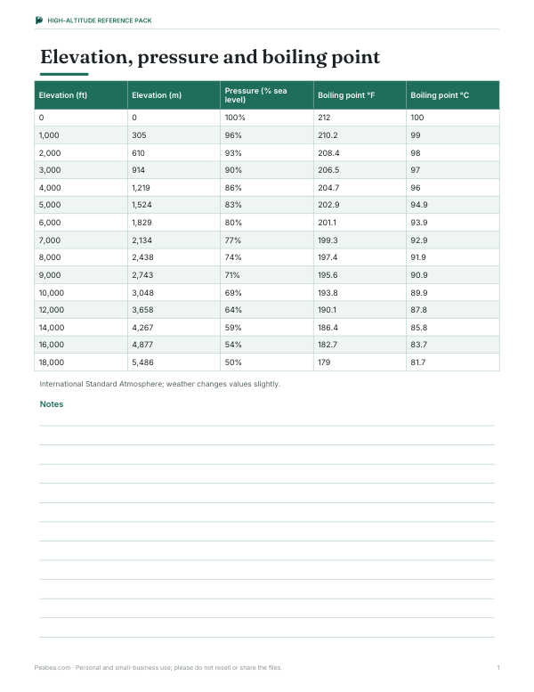
| Elevation | Air pressure (% of sea level) | Water boils at |
|---|---|---|
| 0 ft / 0 m | 100% | 212 °F / 100 °C |
| 2,500 ft / 762 m | about 91% | about 207 °F / 97.4 °C |
| 5,000 ft / 1,524 m | about 83% | about 203 °F / 95 °C |
| 7,500 ft / 2,286 m | about 76% | about 198 °F / 92.4 °C |
| 10,000 ft / 3,048 m | about 69% | about 194 °F / 90 °C |
| 14,000 ft / 4,267 m | about 59% | about 186 °F / 86 °C |
Boiling points use the standard atmosphere and the Antoine equation for water; actual values vary with weather by a degree or so. Lower boiling points mean food takes longer to cook in boiling water, and many recipes include high-altitude adjustments above about 3,000 feet.
Worked example: barometer reading
You’re at a mountain cabin and your barometer reads 840 hPa. The nearest weather station reports a sea-level pressure of 1,013 hPa. The ratio is 840 / 1,013 = 0.829; raised to the power 0.190263 that gives 0.965; one minus that is 0.0350; multiplied by 44,330.8 the result is about 1,550 m, or roughly 5,090 feet. If the weather report had said 1,003 hPa instead, the same reading would give about 1,470 m — showing why using the current local sea-level pressure matters.
Altitude and your body
- Above about 2,500 m (8,200 ft), acute mountain sickness becomes common: headache, nausea, fatigue and poor sleep.
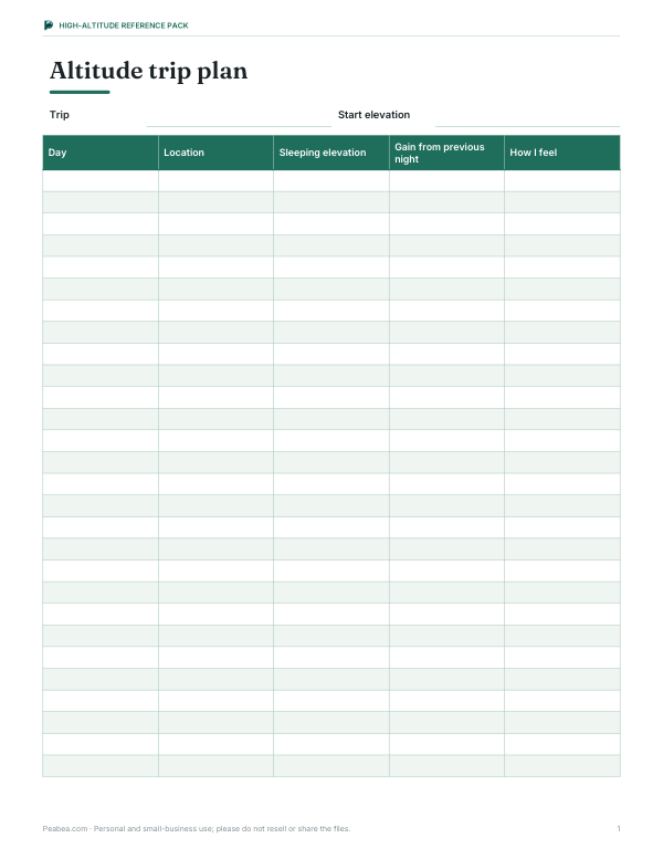
- Ascending gradually — often advised as no more than 300–500 m increase in sleeping altitude per day above 3,000 m — lets the body acclimatise.
- Severe symptoms such as confusion, loss of coordination or breathlessness at rest need descent and medical help.
- The “effective oxygen” figure shows the sea-level oxygen percentage that would give the same oxygen pressure — the air still contains about 21% oxygen at every altitude, but there is less air.
This tool is for information and planning; it isn’t medical advice. People with heart or lung conditions should talk to a doctor before travelling to high altitude.
Elevation for cooking and baking
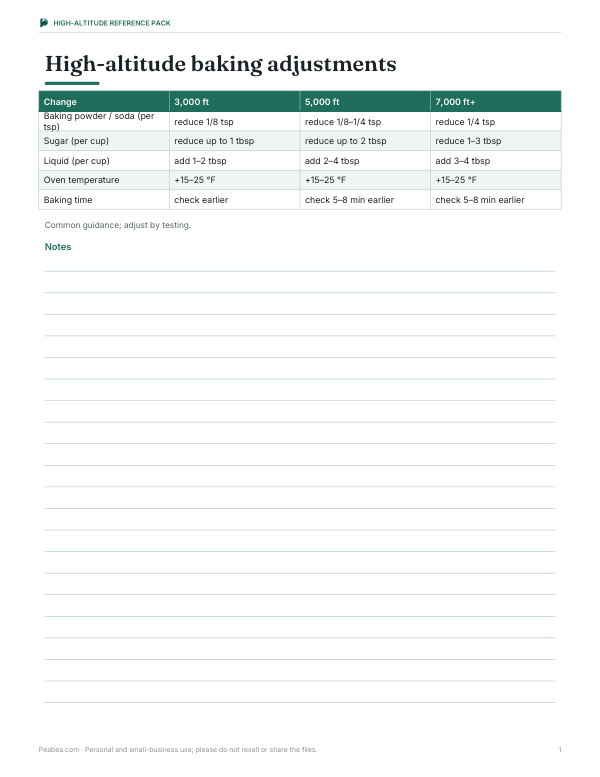
Above about 3,000 feet, cakes can rise too fast and collapse, liquids evaporate faster and boiled foods cook more slowly. Common adjustments include reducing baking powder slightly, raising oven temperature by 15–25 °F, adding a little extra liquid and shortening baking times. Candy and jam recipes that use temperatures should be adjusted by the difference between your boiling point and 212 °F — test by boiling water with your thermometer.
Elevation vs altitude vs height
| Term | Usual meaning |
|---|---|
| Elevation | Height of a point on the ground above mean sea level |
| Altitude | Height of something in the air (or you) above sea level |
| Height | Distance above the local ground |
| Ellipsoidal height | Raw GPS height above a mathematical ellipsoid; phones usually convert it to height above sea level (the geoid) |
The difference between the ellipsoid and sea level (the geoid) ranges from about −106 m to +85 m around the world, which is why raw GPS heights must be corrected.
Place elevations
| Place | Approximate elevation |
|---|---|
| Dead Sea shore (Israel/Jordan) | -1,411 ft (-430 m) |
| Badwater Basin, Death Valley (USA) | -282 ft (-86 m) |
| Amsterdam (Netherlands) | -7 ft (-2 m) |
| New York City (USA) | 33 ft (10 m) |
| London (UK) | 36 ft (11 m) |
| Phoenix (USA) | 1,086 ft (331 m) |
| Atlanta (USA) | 1,050 ft (320 m) |
| Zurich (Switzerland) | 1,339 ft (408 m) |
| Munich (Germany) | 1,703 ft (519 m) |
| Innsbruck (Austria) | 1,883 ft (574 m) |
| Las Vegas (USA) | 2,001 ft (610 m) |
| Madrid (Spain) | 2,156 ft (657 m) |
| Boise (USA) | 2,703 ft (824 m) |
| Calgary (Canada) | 3,428 ft (1,045 m) |
| Tehran (Iran) | 3,904 ft (1,190 m) |
| Salt Lake City (USA) | 4,226 ft (1,288 m) |
| Kathmandu (Nepal) | 4,593 ft (1,400 m) |
| Denver (USA) | 5,280 ft (1,609 m) |
| Albuquerque (USA) | 5,312 ft (1,619 m) |
| Johannesburg (South Africa) | 5,751 ft (1,753 m) |
| Kabul (Afghanistan) | 5,876 ft (1,791 m) |
| Nairobi (Kenya) | 5,889 ft (1,795 m) |
| Colorado Springs (USA) | 6,033 ft (1,839 m) |
| Santa Fe (USA) | 7,198 ft (2,194 m) |
| Mexico City (Mexico) | 7,349 ft (2,240 m) |
| Addis Ababa (Ethiopia) | 7,726 ft (2,355 m) |
| Aspen (USA) | 7,999 ft (2,438 m) |
| Bogotá (Colombia) | 8,661 ft (2,640 m) |
| Quito (Ecuador) | 9,350 ft (2,850 m) |
| Leadville (USA) | 10,151 ft (3,094 m) |
| Cusco (Peru) | 11,152 ft (3,399 m) |
| La Paz (Bolivia) | 11,942 ft (3,640 m) |
| Lhasa (China) | 11,995 ft (3,656 m) |
| Mount Fuji summit (Japan) | 12,388 ft (3,776 m) |
| Pikes Peak summit (USA) | 14,114 ft (4,302 m) |
| Mount Whitney summit (USA) | 14,505 ft (4,421 m) |
| Mont Blanc summit (France/Italy) | 15,768 ft (4,806 m) |
| Kilimanjaro summit (Tanzania) | 19,341 ft (5,895 m) |
| Denali summit (USA) | 20,308 ft (6,190 m) |
| Mount Everest summit (Nepal/China) | 29,032 ft (8,849 m) |
City elevations are approximate reference values — cities often span hundreds of feet between their lowest and highest neighbourhoods.
Privacy
The GPS option uses your browser’s geolocation, which asks for permission first. The position is used only inside this page to show the altitude and is not stored or sent anywhere.
Frequently asked questions
How can I find my elevation?
Use your phone’s GPS altitude, a barometer with the local sea-level pressure, or a topographic map.
Why doesn’t my laptop show an altitude?
Most desktop and laptop browsers locate you by Wi-Fi or IP address, which doesn’t include altitude.
How accurate is GPS altitude?
Typically within about 10–50 metres; vertical accuracy is worse than horizontal.
At what temperature does water boil at 5,000 feet?
About 203 °F (95 °C).
What is the elevation of Denver?
About 5,280 feet (1,609 m) — hence the “Mile High City”.
Is my location sent anywhere?
No. It is used only in your browser.